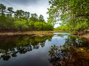
Photo Spot Summary
Country: United States
Category: Landscape
State: Florida
City: White Springs
GPS Latitude: 30.343946
GPS Longitude: -82.737129
Directions
As per Google map (which is accurate): Take exit 439 from I-75 N 43 min (52.2 mi) Continue on FL-136 E. Drive to SE Co Rd 135 in Hamilton County 8 min (4.9 mi). The address of the Big Shoals State Park Address is: 11330 SE Co Rd 135, White Springs, FL 32096
Photo Spot Details
Hike about 1 1/2 miles along the “Palmetto Trail” that runs about 15 feet above river (at least this day). The Suwannee River is on the left, and there are several spots along this trail where you can descend the bank to get to the river bed.
The river was 48 feet which made for calm waters. The river reaches up to level 3 whiter water rapids by 60 – 70 feet or so.
This was shot in early June 2017 on a cloudy day, around 9:45 AM on a tripod with the Nikon D750, 16-35mm f/4G @ 17mm, ISO 200, 25/1, f/18

Appreciate your suggestions for ‘CUSTOM MENU SETTINGS’ in Nikon D850 for Landscape Photography. Thanks.